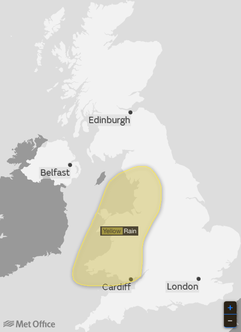
TORRENTIAL downpours will put parts of Britain on flood alert with a month’s rain forecast over the next 24 hours.
Exposed and coastal regions are braced for chilly 50mph gales as Icelandic winds put the blazing start to summer on hold.
Temperatures will take a plunge around the country as weatherman warn the weather is about to “go downhill”.
The Met Office has warned of an “unpleasant week” ahead with nowhere likely to escape almost autumnal conditions.
It has issued severe weather warnings for more than three inches of rain in Wales and the north west over the next 24 hours.

Forecaster Steven Keates warned things were due to “go downhill” last night (Sunday) ahead of a rollercoaster week of foul weather.
Around a month’s rain will soak parts of Britain caught in the heaviest deluges over the coming days, he added.
He said: “It’s going to get noticeably cooler and wetter compared to the past few days, we have been a bit spoilt by the weather. Monday will be a thoroughly wet day.
“There are several depressions coming in off the Atlantic this week and it is going to feel relatively unseasonable and not pleasant at times.
“Virtually everywhere will see rain with 50mph-plus gales a risk in exposed regions and there will be the risk of frost as winds come from a more northerly direction from Iceland.
“It is not going to be the best week for weather.”
He said tomorrow (Tuesday) is shaping up to be the coldest day of the week with severe weather warnings for wind and rain likely through the week.
“Winds could be strong enough to cause disruption,” he said.
“Tuesday will be wet and windy again and with winds coming in from the north it will feel chilly, it is looking like the coldest day of the week.
“Wednesday will start off cold and then on Thursday another low pressure takes aim at southern Britain bringing further rain and strong winds, it is one to keep an eye on.
“Soaking rain will be heavy and persistent enough to cause some issues with surface water.
“It is a similar picture into the weekend and all in all it is going to be a very mixed week with everywhere seeing a difference in the weather from the past few days.”
Met Office chief forecaster Steve Ramsdale said: “A large area of rain is expected to run across the UK through Monday and into Tuesday.
“A band of this is expected to become slow moving over parts of the highlighted area with heavy elements running through it.
“This has the potential to give 80 mm of rainfall in a few places during Monday.”
The dramatic u-turn will come as a shock to the system to Britons who have baked in unusually warm weather over the past week.
Thousands of people flocked to parks, beaches and open-air events at the weekend as the mercury soared.
The change in weather is being blamed on the jet steam taking a sharp southwards opening the floodgates to cold, Atlantic winds.
Scotland and the north are first in line for the bad weather this week before wind and rain work through the country.
Even exposed parts of the south could see a touch of frost by the end of the week, forecasters have warned.
Temperatures will struggle to get much above 20C (68F) or 21C (69.8F) across the region this week sinking below double figures overnight.
Scotland and the north will see highs of around 15C (59F) during the day with lows of around 2C (35.6F) or 3C (37.4F) overnight.
WeatherOnline forecaster John Ejdowski said: “With the jet stream running just to the south of Britain, it will develop fairly deep Atlantic low pressure areas to the west of Ireland.
“The lows and associated weather fronts will often bring in spells of heavy rain and gusty winds.
“Temperatures will be below normal until late in the week.”
©NathanRaoMedia
