


BRITAIN could be looking at another hammering from the elements with the “seeds” of yet more tropical storms currently sprouting near the Atlantic.
Forecasters last night said they have spotted signs of a “hurricane-force” storm brewing off the coast of Africa threaten to disrupt Britain’s calm autumn weather later this month.
If it develops it is likely to swing northwards with Europe and the UK in the firing line in around 10 to 12 days, they added, though said it is far too early to start panicking.
The warning comes as Britain enjoys a relatively settled period of weather with the rest of the week looking warm and dry for most.
Experts, including Channel 4's Liam Dutton, said computer models will be “closely monitored” over the next week with the risk of a serious autumn storm “not to be ignored”.
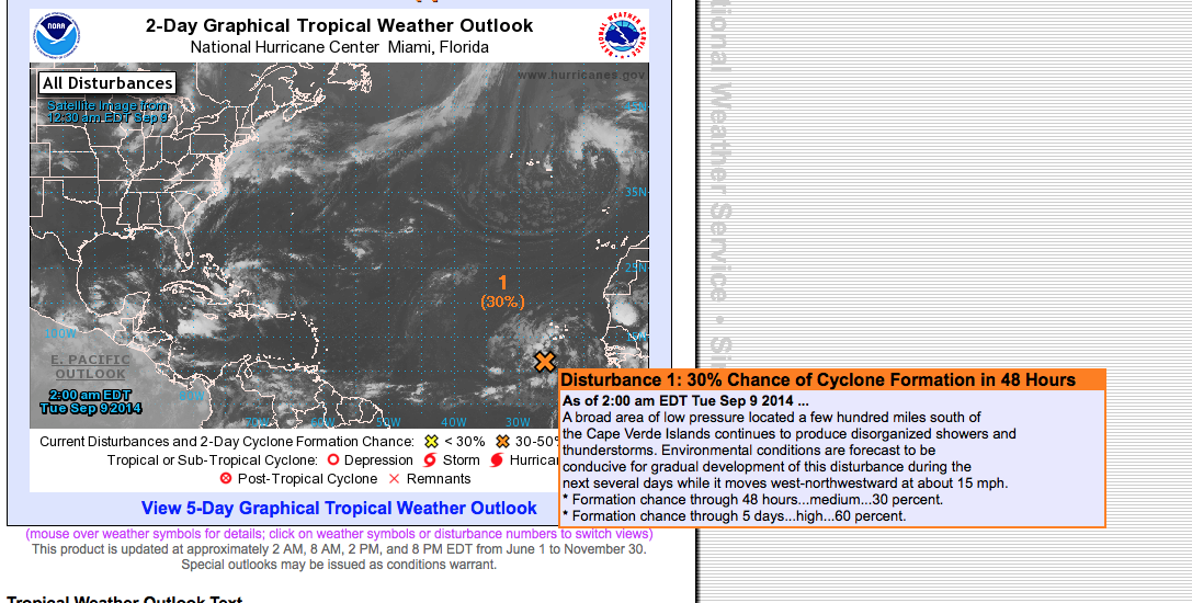
Leon Brown, forecaster for The Weather Channel, said: “We will be watching tropical disturbances later this week moving off central Africa to the mid Atlantic.
“If any tropical storms do develop they would steer northwestwards then curve northeastwards towards northern Europe in about 10 to 12-days time and have an impact on our weather.
“High pressure will dominate our weather this week, and the coming weekend, with dry weather across the UK.
“Cool nights, particularly in the north, under clear skies and with light winds.”
The Met Office said it was “too early to forecast in any great detail” whether Britain will be hit by another tropical storm.
Its six to 30-day outlook warns of “frequent bouts of unsettled weather” this month.
It states: “During late September, and into October most regions can expect to see periods of fine weather, with some pleasantly warm sunshine at times.
“However, these fine periods are likely to be interspersed with occasional spells of cloudier, more unsettled conditions with showers or longer spells of rain.
“Western parts are probably most likely to see the more frequent bouts of unsettled weather, leaving eastern parts most probably seeing the better fine and dry spells.
“Daytime temperatures are likely to be near or slightly above average during fine weather leaving conditions feeling pleasantly warm.”
In August ex-Hurricane Bertha unleashed torrential downpours and gales after sweeping in from the east coast of the Untied States.
The remnants of Hurricane Cristobal then tracked over northern Europe bringing wind and rain to Scotland but dragging high pressure and milder conditions across the rest of the UK.
On his blog meteorologist Liam Dutton said although “unlikely”, a serious storm this month could not be completely ruled out.
He said: “The seeds of the hurricane-force storm that the weather computer model has generated in two weeks are only just moving off the west coast of Africa and have to overcome many hurdles in order to develop.
“The remnants of whatever storm happens to form needs to interact with the jet stream at precisely the right time and position over the mid-Atlantic Ocean in order to deepen explosively.
“What this weather computer model has shown us meteorological folk is that in two weeks’ time, the ingredients will be present to deliver the potential for some wet and very windy weather.
“During the coming seven -10 days, weather computer models from all around the world will be closely monitored to hone in on the detail as things become clearer closer to the time.
“[It’s an] unlikely outcome, but not to be ignored.”
WeatherOnline forecaster John Ejdowski said: “High pressure will be the main weather feature across the country and this will give a mainly dry week ahead.
“While there will often be a good deal of cloud, there will be sunnier days.
“Towards the cloud may be thick enough to produce some morning drizzle as a north east wind develops. Temperatures are likely to be at or above normal.”